In 2019, the Neureuter family’s hopes for restoring the marine ecosystem received a major boost with the formation of The Noises Marine Restoration Project, a partnership between the family trust, Tāmaki Paenga Hira Auckland War Memorial Museum and Waipapa Taumata Rau The University of Auckland.
The project was financially supported by Foundation North’s Gulf Innovation Fund Together, Pew Bertarelli Ocean Legacy and the C&L Gregory Trust. There were significant contributions of staff time and support from the partner institutions.
The ambition for The Noises Marine Restoration Project was bold:
To enable restoration and regeneration of the marine environment surrounding The Noises islands, to deliver holistic protection of the land and the sea.
Inspired by the vision of Sea Change, this work is about the revitalisation of mauri.
Government Strategy
The Government proposed to create new marine protected areas in the Hauraki Gulf Marine Park, using special legislation. The Government’s intentions, outlined in Revitalising the Gulf – Government action on the Sea Change Plan (pdf), were released in June 2021.
The Government introduced a new marine protection term called “High Protection Area” (HPA). An HPA provides the highest level of protection, while still providing for customary practices by iwi.
The Government initially nominated 11 sites to be HPAs. In addition, The Noises was included in the list of proposed new areas for marine protection, however, the type of protection was left undefined on the basis that there is a “Proposal still under development through a community-led project”.
The Government Strategy further explained:
The Sea Change Plan proposal for a Noises MPA [marine protected area] is being developed by a community-led project, which was cited by several stakeholders during our engagement discussion as an outstanding example of what can be achieved through co-operation and participation. Once developed, a proposal for marine protection at The Noises may be included in our public consultation process.
In August 2021, The Noises Marine Restoration Project team was invited to submit a proposal for The Noises to be included in the Government’s special legislation package. In September 2021, a submission was provided to Government and was then assessed by the Department of Conservation and Fisheries NZ. If you’d like to view a copy of the initial submission to Government please email Sue Neureuter.
In September 2022 the Government released a consultation document and sought feedback on a package of marine protection proposals, including an HPA around The Noises.
Following the Government’s consideration of the feedback received, special legislation was introduced into Parliament to create the new marine protected areas as a single package.
The Noises Marine Restoration Project team then submitted to the [Sept 2022] Government consultation process. You can read our submission here: Submission from The Noises Marine Restoration Project – 071022
The Noises proposal
Outlined below are some of the key pieces of information about The Noises HPA.
How was the proposed boundary developed?
The boundaries of the proposed HPA at The Noises were based on the Government’s Site Identification and Protected Area Design Guidelines. The boundaries drew on knowledge of species assemblages and the extent of key habitats from the 2017 and 2021 marine surveys. This data was supplemented by local observational knowledge gained by members of the Neureuter family over more than 80 years, and scientific evidence gathered from over 40 years of monitoring and research in northern New Zealand marine reserves.
The Noises are characterised by extensive subtidal reefs that connect many of the islands and rock stacks. The Design Guidelines recognised the importance of including entire reef systems within marine protected areas so that marine ecosystems and their inhabitants are effectively protected. This included incorporating the known seasonal movements of critical reef species such as kōura/crayfish that move into sandy habitats adjacent to the reefs for reproduction and foraging. In the case of kōura/crayfish, these movements often take them 1-2 km beyond the reef edge. To adequately protect certain “reef-associated” species, protected areas need to include significant areas of adjacent sandy habitats as a “buffer”.
The Design Guidelines further recommended protected areas are of sufficient size to provide for the maintenance of populations of plants and animals. The guideline states that this “helps maintain healthy self-sustaining populations resilient to ‘edge effects’ resulting from use of the surrounding / adjacent areas”. The impact of edge effects for many target species (e.g. tāmure /snapper and kōura / crayfish) extends ~1 km into protected areas this ultimately means that areas within 1 km of a boundary are not effective at protecting these species.
The 2 km radius areas (shown in blue) were positioned around each of the islands, reefs and habitats of interest to accommodate both seasonal movements of critical reef species onto sandy habitats (a “buffer”) and mitigate the impact of edge effects.
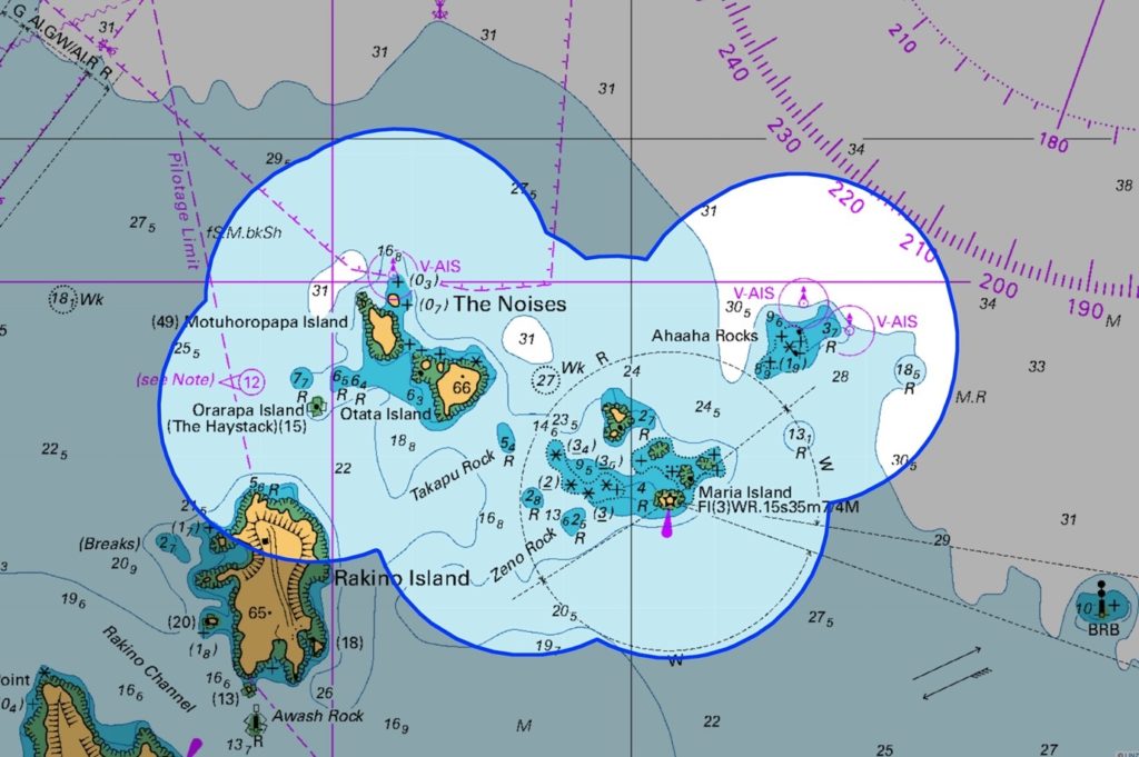
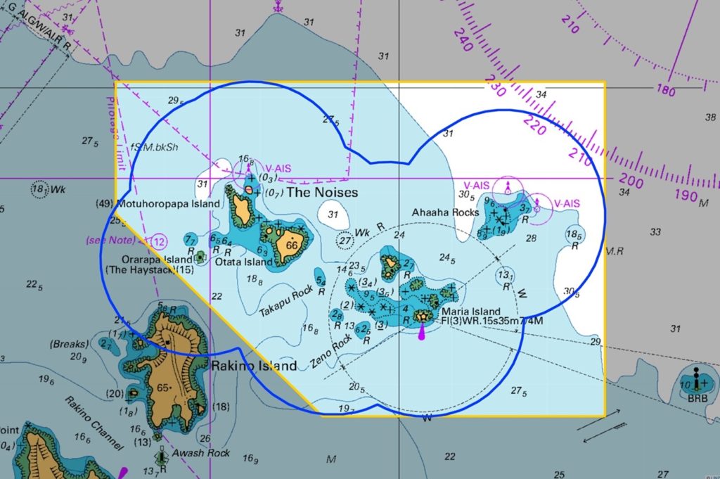
To provide a marine protected area with boundaries that are easily understood, a more symmetrical shape was proposed that still encompasses entire reef systems, shown here in yellow.
The resulting design encompasses an area of approximately 60 km2 or 6000 ha and now represents 0.5% of the Hauraki Gulf Marine Park.
What are the critical marine biodiversity values?
The Noises is considered to be a highly productive part of the Hauraki Gulf due to its geography and associated oceanography. The Noises is a complex group of islands, rock stacks and subtidal reefs that traverse both inner and outer Gulf waters. As such, the productivity of The Noises is strongly driven by the interplay between upwelled ocean driven nutrients from the outer Gulf, and catchment driven nutrients of inner Gulf waters, which in turn supports high benthic rocky reef and soft sediment biodiversity. Based on its location, The Noises is expected to be a larval supply hotspot for the Hauraki Gulf.
Since Sea Change Tai Timu Tai Pari two marine surveys have been conducted which confirmed the regionally significant range of marine habitats around The Noises. These include intertidal and subtidal mussel beds, biogenic habitats including macroalgae forests, diverse sessile invertebrate communities, rhodolith beds, and large soft sediment bivalve beds (such as dog cockles).
Together these complex habitats translate to very high marine diversity over a relatively small geographical area.
The surveys also reported alarming degradation. The 2021 marine survey noted low density of legal-sized reef fish, with reef fish biodiversity assessed as low to moderate; clear impacts from sedimentation across all the survey sites; expansive areas of kina barrens; and very low tipa/scallop density, with only 31 legal-sized individuals encountered over 1 km2. Despite high quality habitat for kōura/crayfish and extensive searches, only three kōura/crayfish were observed, and all were below legal size.
While present-day reef fish abundance, size, and diversity is alarming, the array of biogenic habitats, coupled with the existing geological and hydrodynamic settings, unequivocally point to a system that can recover if given the chance. This applies to areas larger than 50km2 and The Noises HPA, established in October 2025 is approximately 60km2.
Collectively, these physical and biological attributes gave further weight to the area being prioritised for marine conservation and regeneration efforts.
What are the benefits of a HPA at The Noises?
It is anticipated there will be multiple benefits from marine protection surrounding The Noises islands including:
- Protecting and enhancing important ecological linkages between terrestrial and marine habitats.
- Protecting all species within the boundary from some adverse impacts
- Protecting and enhancing a diverse range of regionally significant sand and soft sediment habitats and associated biological communities, including Kutai/mussels, tipa/scallops, rhodoliths, dog cockles and horse mussels.
- Contributing research and knowledge to the Hauraki Gulf.
- Enhancing the abundance of marine species beyond the protected area through the spillover effect and larval transport. (see initial study from Moana Research here).
- Supporting the restoration of a larger mussel population in the Gulf with a critically important natural seed source.
- Providing for Treaty partners, whānau, hapu and iwi to exercise rangatiratanga and kaitiakitanga.
- Enabling opportunities for education in an environment of recovery.
- Enabling opportunities for controlled marine eco-tourism in an environment of recovery.
- Enabling opportunities for regeneration, sharing and continuation of mātauranga Māori.
- Enabling aspirational goal setting including the restoration of locally extinct iconic species such as hapuku and kōura/crayfish.
The Noises Trust is committed to enabling and supporting further research to identify ways in which the benefits from protection and regeneration can be maximised over a larger geographic area.

The Noises HPA proposed boundary, shown in yellow.